Geography; Nature and climate; Demography; History; Wars;
Culture ; Art; Film; Music; Politics; Political parties ; Defense;
Peace movements; Religion; Social conditions ; Education ,
Economics and Arms trade.
Géographie; Nature et climat; Démographie;
Guerres; Histoire; Culture ; La musique; Politique; Partis
politiques ; La défense; Mouvements de paix; Religion;
Conditions sociales ; Éducation; Économie et commerce
des armes
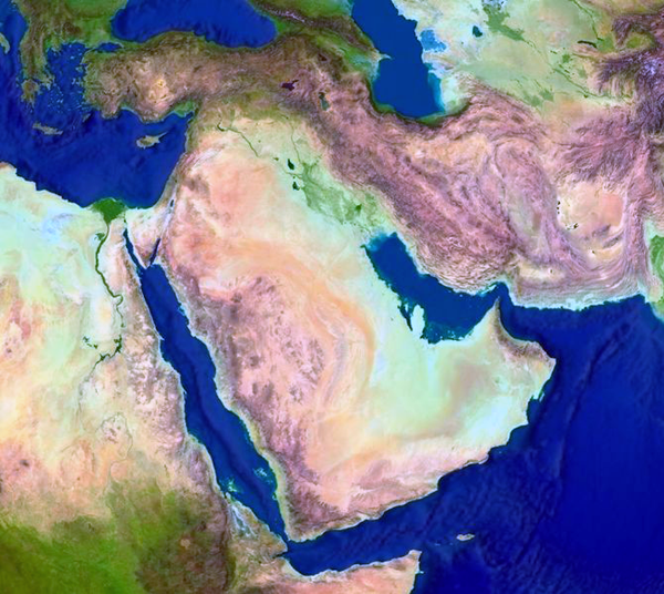
Egypten er en
nordøstafrikansk og
mellemøstlig arabisk
republik, militærdiktatur og
autokratiskpolitistat,
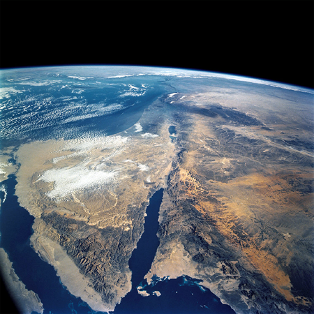
hvis territorium omfatter Sinai
halvøen som adskilles fra Egypten ved Suezkanalen - med
kystlinjer til Middelhavet og Det røde hav. Grænser til Libyen,
Israel, Palæstina og Gaza samt
Sudan i syd. Del af Levanten. Til Egypten hører
Sinai-halvøen ved det Røde Hav mellem Suezbugten mod
vest og Akababugten mod øst. Området nord for den
egentlig halvø op til Middelhavet afgrænset af
Suez-kanalen mod vest og den egyptisk-israelske grænse mod
øst. Halvøen er den vestligste del af Asien.
Suezbugten adskiller Sinai-halvøen fra Afrika i den nordlige
ende af det Røde Hav. Længst mod nord er havnebyen
Suez og indgangen til Suez-kanalen.
For de gamle egyptere var Elefantine eller Elefantøen i
Nilen sydgrænsen til Nubien, det sorte Afrika.
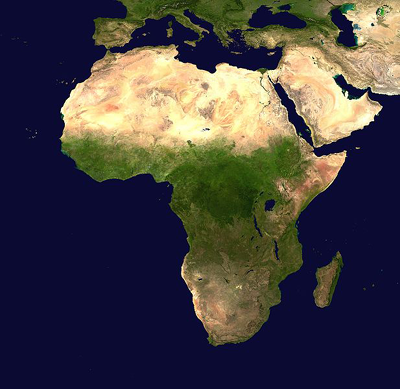
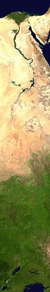
Egypten er og har historien igennem været et strategisk vigtigt geopolitisk trafikknudepunkt mellem Europa og Asien.
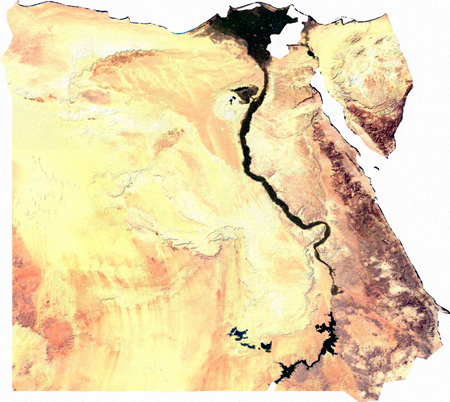
Egypten dækker et område på omkring en million
kvadratkilometer og kan opdeles i fire fysiografiske regioner:
Nil-dalen, Den vestlige ørken, Den østlige
ørken og Sinai. Den tørre ørken dækker
92% af jorden, de resterende 8% af agerjord er begrænset til
Nildalen, Nil-deltaet og et par oaser spredt i den vestlige
ørken.
North African and Middle Eastern Arab Republic, military
dictatorship and autocratic police state, whose territory includes
the Sinai peninsula separated from Egypt by the Suez Canal - with
coastlines on the Mediterranean and the Red sea. Borders to Libya,
Israel, Palestine and Gaza and Sudan in the south. Part of the
Levant. To Egypt belongs the Sinai Peninsula in the Red Sea between
the Bay of Suez to the west and the Gulf of Aqaba to the east. The
area north of the actual peninsula on the Mediterranean is bounded
by the Suez Canal to the west and the Egyptian-Israeli border to
the east. The peninsula is the westernmost part of Asia. The Gulf
of Suez separates the Sinai Peninsula from Africa in the northern
end of the Red Sea. In the far north is the port city of Suez and
the entrance to the Suez Canal. For the ancient Egyptians were
Elephantine or the Elephant island in the Nile the south border to
Nubia, the black Africa.
Egypt covers an area of about one million square kilometers and can
be divided into four physiographic regions: the Nile Valley, the
Western Desert, the Eastern Desert and Sinai. The arid desert
covers 92% of the land, the remaining 8% of arable land being
restricted to the Nile Valley, the Nile Delta and a few oases
scattered in the Western Desert.
Egypt is and has throughout history been a strategically important
geopolitical hub between Europe and Asia.
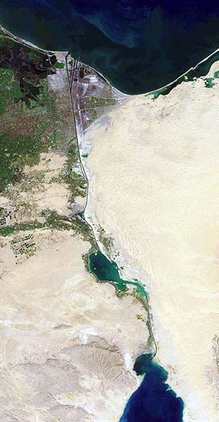
Suez kanalen / Suez Canal
- https://archive.org/search.php?query=Suez%20Canal
'One of the most important waterways in the world, the Suez Canal
runs north to south across the Isthmus of Suez in northeastern
Egypt. This image of the canal covers an area 36 kilometers (22
miles) wide and 60 kilometers (47 miles) long in three bands of the
reflected visible and infrared wavelength region. It shows the
northern part of the canal, with the Mediterranean Sea just visible
in the upper right corner. The Suez Canal connects the
Mediterranean Sea with the Gulf of Suez, an arm of the Red Sea. The
artificial canal provides an important shortcut for ships operating
between both European and American ports and ports located in
southern Asia, eastern Africa, and Oceania. With a length of about
195 kilometers (121 miles) and a minimum channel width of 60 meters
(197 feet), the Suez Canal is able to accommodate ships as large as
150,000 tons fully loaded.'.
Convention Respecting the Free Navigation of the Suez Maritime
Canal
Constantinople Convention, 1888
Convention between Great Britain, Germany, Austria-Hungary, Spain,
France, Italy, The Netherlands, Russia and Turkey, respecting the
free navigation of the Suez maritime canal signed at
Constantinople, October 29, 1888.
-
http://www-rohan.sdsu.edu/dept/polsciwb/brianl/docs/1888ConstantinopleConventionon.pdf
'Article I:
The Suez Maritime Canal shall always be free and of commerce or of
war, without distinction of flag. Consequently, the High
Contracting Parties agree not in any way to interfere with the free
use of the Canal, in time of war as in time of peace. The Canal
shall never be subjected to the exercise of the right of
blockade.'
Actes constitutifs de la Compagnie universelle du canal de Suez. /
: Compagnie financière de Suez, 1866.
- https://archive.org/details/bub_gb_lb1IAAAAMAAJ
Geografihistoriske primærkilder og fremstillinger /
Geography Historical primary sources and
presentations /
Géographie des sources historiques primaires:
Ptolemy's Geography, Book 4. : The Geography by Claudius
Ptolemy, Greek geographer of the 2nd century A.D., translated by
Edward Luther Stevenson (New York, 1932). Book 4: Africa:
Mauritania Tingitana, Mauritania Caesariensis, Numidia, Africa
Cyrenaica, Marmarica (Libya), Egypt Lower and Upper, Libya Interia,
Ethiopia below Egypt, Ethiopia, interior. Graphics in zipped HTML
files prepared by Robert Bedrosian.
- http://www.archive.org/details/PtolemysGeographyBook4
Tabula Peutingeriana
- http://www.euratlas.net/cartogra/peutinger/index.html
Frederik Ludvig Norden: Drawings of some ruins and colossal statues
at Thebes in Egypt, with an account of the same in a letter to the
Royal Society. (1741).
- http://www.archive.org/details/drawingssomerui00nordgoog
Sefer nameh; relation du voyage de Nassiri Khosrau en Syrie, en
Palestine, en Égypte, en Arabie et en Perse, pendant les
années de l'Hégire 437-444 (1035-1042) Publié,
traduit et annoté par Charles Schefer. - Paris: E. Leroux,
1881.
- https://archive.org/details/sefernamehrelati01nasiuoft
Frederik Ludvig Norden: Rejse i Egypten og Nubien. / : Frederik
Ludvig Norden. Kaptajn i den kongelige flåde.
Rejsebeskrivelse forsynet med kort og tegninger udført
på stederne af forfatteren selv. Oversat af Kim Witthoff fra
den franske førsteudgave. København 1755. Indledt af
Paul John Frandsen og udsendt af Det Kongelige Danske
Videnskabernes Selskab, Vandkunsten. 2010. - ISBN
978-87-7695-127-6. Rejsebeskrivelsen er den første danske
oversættelse af Voyage d'Egypte et de Nubie,1755.
Et pragtværk om den danske søofficer Frederik Ludvig
Nordens rejse til Egypten og Nubien i 1737-1738. Værket udkom
oprindeligt på fransk i 1755 og var kendt af såvel
Carsten Niebuhr som Napoleon. Det vakte en stor interesse for
Egypten og dets oldtidsmonumenter i samtiden og var med til at
forberede det senere arkologiske gennembrud.
-
https://archive.org/search.php?query=Frederik%20Ludvig%20Norden Chr. Bendix Thostrup.: Frederik Ludvig Norden.
En dansk Forskers Pioner arbejde i Ægypten. Geografisk
Tidsskrift, Bind 41 (1938).
Carsten Niebuhr ekspeditionen. Stig T. Rasmussen [red]: Den
arabiske rejse 1761-1767: En dansk ekpedition set i
videnskabshistorisk perspektiv. Rosinante, 1990.
Se desuden:
- http://www.kb.dk/da/nb/samling/os/naeroest/cneksp.html
Main Map of Ancient Egypt.
-
http://www.mnsu.edu/emuseum/prehistory/egypt/maps/mainmap.html
Bruce, James: Travels to discover the source of the Nile : in the
years 1768, 1769, 1770, 1771, 1772, and 1773.Vol. I-VI.
-
http://archive.org/search.php?query=creator%3A%22Bruce%2C+James%2C+1730-1794%22
- Dublin : Printed by William Sleater, for P. Wogan, L. White, P.
Byrne, W. Porter, W. Sleater, J. Jones, J. Moore, B. Dornin, C.
Lewis, W. Jones, G. Draper, J. Milliken, and R. White, 1790.
'Vol. 3 printed by William Porter, v. 5 by Graisberry and Campbell,
and v. 6 by Zachariah Jackson Vol. 6 has title: Select specimens of
natural history collected in travels to discover the source of the
Nile, in Egypt, Arabia, Abyssinia, and Nubia.'
Voyages au Soudan oriental, dans l'Afrique septentrionale et
dans l'Asie mineure, exécutés de 1847 à 1854,
comprenant une exploration dans l'Algérie, les
régences de Tunis et de Tripoli, l'Asie Mineure, l'Egypte,
la Nubie, les déserts, l'ïle deMéroé, le
Sennar, le Fa-Zoglo, et dans les contrées inconnues de la
Nigritie Texte. / Pierre Trémaux. - Paris : L. Hachette,
1862-1863.
- http://www.wdl.org/en/item/2550/
'Pierre Trémaux (1818-95) was a French architect, traveler,
photographer, and amateur scientist who, in 1847-48, voyaged up the
Nile to Nubia, Ethiopia, and eastern Sudan. Trémaux
described the geology, flora and fauna, architectural monuments,
and people of these countries in several works published in France
in the 1850s and early 1860s. Some scholars consider his
descriptions and sketches of Lower Nubia to be especially valuable,
since much of this area now is covered by Lake Nubia, the extension
into Sudan of Lake Nasser, created when the Aswan High Dam was
built in the 1960s.'